Map of the Month: A deep dive into my illustrated maps
- Nicola Hawley

- Feb 23, 2024
- 3 min read
My map of the month for this month is S G Maclean's map for her book The Bookseller of Inverness, read this blog for a deep dive into its creation!
Contents:

BOOK SUMMARY
The Bookseller of Inverness is set ten years after the Battle of Culloden in Inverness. Its central character is a scarred bookseller, who fought in the Battle of Culloden and has no wish to revive it. Yet, there are whispers that Bonnie Prince Charlie gathers his men to fight again.
STARTING THE MAP
When I was first asked to create this map, I absolutely jumped at the chance. One of my (most random) favourite books ever is set during the second uprising of Bonnie Prince Charlie, and is called Born To Be King by Constance Gluyas. While it is a fictional novel, I also felt totally immersed in the time period when reading, and I loved how it evoked the belief of the Scottish people in the prince.
So, when I was asked to create a map of the time period for S G Maclean, I had an image straight away of what I wanted the map to look like, and it included lots of little easter eggs from the Jacobite cause.

JACOBITE SYMBOLS
Fortunately, The Bookseller of Inverness had lots of symbols I could draw on to represent the Jacobites, but I also wanted to do my research, and so I embarked on a journey to discover them myself.
I included the toast 'To the King over the water', which referenced Bonnie Prince Charlie's exile in Europe, and the words 'fiat redi' - a latin phrase that expressed hope for the king's return.
I also included the white cockade: a symbol of Jacobite rebellion, and often pinned to clothes for Jacobites to identify one another.
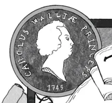
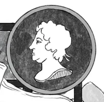
I included portraits of King George and the white Hanoverian horse on one side of the map, and Charles and James with the white cockade on the other side, literally opposing one another.
There's also an oak tree at the top of the border with the words 'look, love and follow' above it, another symbol of the Jacobites, and which features heavily in the book itself.
There is also, of course, the Scottish thistle, the design of which was taken from a picture of a mantlepiece of a possible Jacobite sympathiser.
RESEARCHING LANDSCAPE
I also researched maps from the time period and took the style of the writing and the layout of the landscape from one particular map that I now can't find the link to (d'oh!). so it was all as accurate to the time as possible.
Luckily, this time period saw a great boom in maps of Scotland, as England tried to record it in order to suppress it.

LOCATIONS
The highlighted locations were all picked out by Shona as important for the book, and I had to do research on these too, to find out how they looked at the time. I did actually get it wrong in one instance though! Luckily Shona caught it and reminded me that Fort George didn't actually exist yet, so I had to add in the words 'Plan of', to make it a 'plan of Fort George!
The little building in Inverness is our main character (Ian's) bookshop, and was entirely pieced together out of pictures Shona provided, that were used as inspiration for the shop.
If you enjoyed this deep dive into the creation of one of my illustrated maps, then please check out my other deep dives! I have one for Stef Penney's Beasts of Paris map, and one for Andrew Caldecott's Simul Map.
Let me know what you think below, or if you have any questions!
And as always, thanks for reading!
Nx


Comments